Elios 3: A Revolutionary Drone for Mining Operations
Mining is one of the most challenging and hazardous industries in the world. It requires constant monitoring, inspection, and surveying of underground and inaccessible areas. However, traditional methods of data collection are often time-consuming, costly, and risky for workers. That is why many mining companies are looking for innovative solutions to streamline their operations and improve their safety standards.
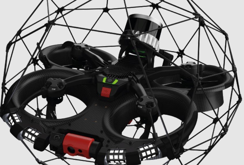
One of the most promising technologies in this field is the Elios 3, a collision-tolerant drone equipped with a rotating LiDAR sensor and a high-resolution camera. The Elios 3 is designed to fly in confined and complex spaces, such as tunnels, shafts, ore passes, and stopes. It can capture visual and metric data in all directions, even without GPS, and generate accurate 3D models and maps of the surveyed areas.
The Elios 3 is powered by GeoSLAM Connect, a software platform that integrates the data from the drone with the GeoSLAM Beam SLAM algorithm, which enables fast and precise localization and mapping. GeoSLAM Connect also allows users to process, visualize, and export the data in various formats, such as point clouds, meshes, orthophotos, and CAD drawings.
How can Elios 3 benefit mining operations?
The Elios 3 offers several advantages for mining operations, such as:
- Accessibility: The Elios 3 can access areas that are unsafe or impossible for humans or other equipment to reach, such as no-go zones, hang-ups, blockages, and backfilling gaps. It can also fly in dark and dusty environments, thanks to its powerful LED lights and thermal camera.
- Efficiency: The Elios 3 can collect data in minutes rather than hours and deliver it in real-time or offline, depending on the connectivity. It can also reduce the downtime and costs associated with traditional surveying methods, such as CMS, laser scanners, or manual measurements.
- Safety: The Elios 3 can reduce the exposure of workers to hazards such as falls, collapses, explosions, or toxic gases. It can also provide early warning and detection of potential risks, such as convergence, cracks, or instability.
- Accuracy: The Elios 3 can provide high-resolution and high-density data, with a global accuracy of up to 2 cm and a local accuracy of up to 1 cm. It can also perform various calculations and analyses, such as volumetric measurement, rock mass classification, change detection, and cut and fill estimation.
Some Applications of Elios 3 in Mining
The Elios 3 can be used for a range of applications in mining, such as:
- Mapping and surveying of hazardous areas: The Elios 3 can map and georeference existing workings, such as tunnels, galleries, and shafts, to plan for further development or maintenance. It can also provide accurate and updated information on the geometry and condition of the infrastructure.
- Stockpile volume tracking and reconciliation: The Elios 3 can measure the volume and shape of stockpiles, both indoor and outdoor, and compare them with the expected values. It can also help optimize the production, beneficiation, and logistics processes.
- Monitoring of underground shafts and ore passes: The Elios 3 can monitor the status and performance of shafts and ore passes and detect any anomalies, such as hang-ups, blockages, or wear and tear. It can also help plan and execute the removal of the obstructions and verify the results.
- Inspection of equipment and machinery: The Elios 3 can inspect and assess the condition and functionality of various equipment and machinery, such as conveyor belts, ball mills, SAG mills, crushers, and stockpile feeders. It can also help identify and prevent any failures or malfunctions.
Conclusion
The Elios 3 is a revolutionary drone that can streamline mining operations with visual and metric data from inaccessible places. It can enhance the safety, efficiency, and accuracy of mining activities and provide valuable insights for decision-making and problem-solving. The Elios 3 is a product of Flyability, a Swiss company that specializes in indoor and confined space drones, and GeoSLAM, a UK company that develops 3D geospatial software solutions.
Orion Vale (administrator)
Orion Vale stands out as a senior content writer at RTD Journal, bringing with him a rich background as an SEO Specialist with experience in many prominent companies. His expertise in search engine optimization complements his exceptional writing skills, allowing him to craft content that is not only insightful and engaging but also ranks well in search results. Orion’s strategic approach to content creation, combined with his knack for storytelling, has significantly contributed to RTD Journal's online presence and readership growth. His ability to intertwine SEO best practices with compelling narratives makes him a pivotal member of the team, ensuring that the site's content reaches the widest possible audience.


